The GPS will image the Galactic plane round half the sky, covering 1800 sq. degs in JHK to a depth K=19.0. The K-band depth will be built up in three passes, to identify variability and measure proper motions over a period of several years. Additionally 300 sq. degs of the Taurus-Auriga-Perseus (T-A-P) star-formation complex will be scanned three times through a narrow-band H2 filter (2.12µm).¹ The GPS will require 186 nights of UKIRT time over 7 years. The parameters of the survey are summarised in the table below. The GPS Survey Head is Phil Lucas.
¹ Broad-band JHK imaging of this field is planned as part of the GCS.
| 7-year plan | Filter | Area sq. degs |
Mag. limit (Vega) |
t(exp.) | t(total) | Nights |
|---|---|---|---|---|---|---|
| Galactic Plane Survey GPS |
J | 1800 | 20.0 | 80s | 286h | 186 |
| H | 19.1 | 80s | 286h | |||
| K | 19.0 | 40x3s | 495h | |||
| H2 | 300 | ... | 150x3s | 237h |
The principal goals of the GPS are 1: creation of a legacy database and 3-D atlas, 2: study of star formation and the IMF with emphasis on environmental dependence, 3: counterparts to X-ray sources, high-energy astrophysics, 4: AGB stars, PPN, and planetary nebulae, including detection of brief phases of stellar evolution, 5: brown dwarfs. The science goals are described in detail on the science case page (dated Nov. 2001).
The selected fields are shown in Fig. 1 below. The main aim is to survey as much of the band of Galactic latitude |b|<5o as reasonably possible. UKIRT cannot observe north of Dec +60o, and we have imposed a southern limit Dec >-15o, as shown. These constraints define two sections of Galactic latitude, which are 15o<l<107o, and 142o<l<230o. There will be in addition a narrow extension through the Galactic centre, within |b|<2o, covering Galactic latitudes -2o<l<15o. The Galactic bulge will be explored by surveying a thin stripe extending upwards in latitude from the Galactic centre.
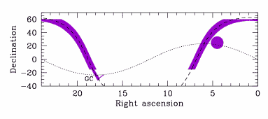
Figure 1. Planned final
GPS sky coverage. The dashed line marks the Galactic plane, and the
dotted line marks the ecliptic. The broad bands are the strips within
|b|<5o. The narrow extension
|b|<2o passes through the Galactic centre
(17h46m,
-28o56' (J2000), marked GC). The thin stripe
extending perpendicular explores the bulge. The large filled circle
marks the location of the T-A-P star-formation complex that will be
surveyed in the line of H2.
The UKIDSS plan for the first two years of operation is based around an allocation of 290 nights of observing, which is 31% of the 936 nights required to complete the surveys. In the first two years the GPS will receiving 57 nights, which is 31% of the total 186 nights required. The strategy is to concentrate on the region of the inner Galaxy, close to the plane, |b|<1o. The parameters of the 2-year plan are summarised in the table below.
| 2-year plan | Filter | Area sq. degs |
Mag. limit (Vega) |
Fraction completed |
Nights | Fraction total nights |
|---|---|---|---|---|---|---|
| Galactic Plane Survey GPS |
J | 780 | 20.0 | 0.43 | 57 | 0.31 |
| H | 19.1 | 0.43 | ||||
| K | 19.0 | 0.14 | ||||
| H2 | 300 | ... | 0.33 |
The fields for the first two years are shown in Fig. 2 below. The region |b|<1 in the longitude range -2o<l<107o will be imaged in JHK. This includes the region to be covered by the GLIMPSE survey using SIRTF. Also two blocks, covering the longitude ranges 30o<l<62o and 160o<l<185o, will be imaged over the full thickness, |b|<5. The bulge fields are also part of the 2-year plan. Finally the first pass of the H2 imaging of the T-A-P star-formation complex will be completed.
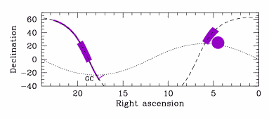
Figure 2. Planned GPS
2-year sky coverage. The dashed line marks the Galactic plane, and the
dotted line marks the ecliptic.